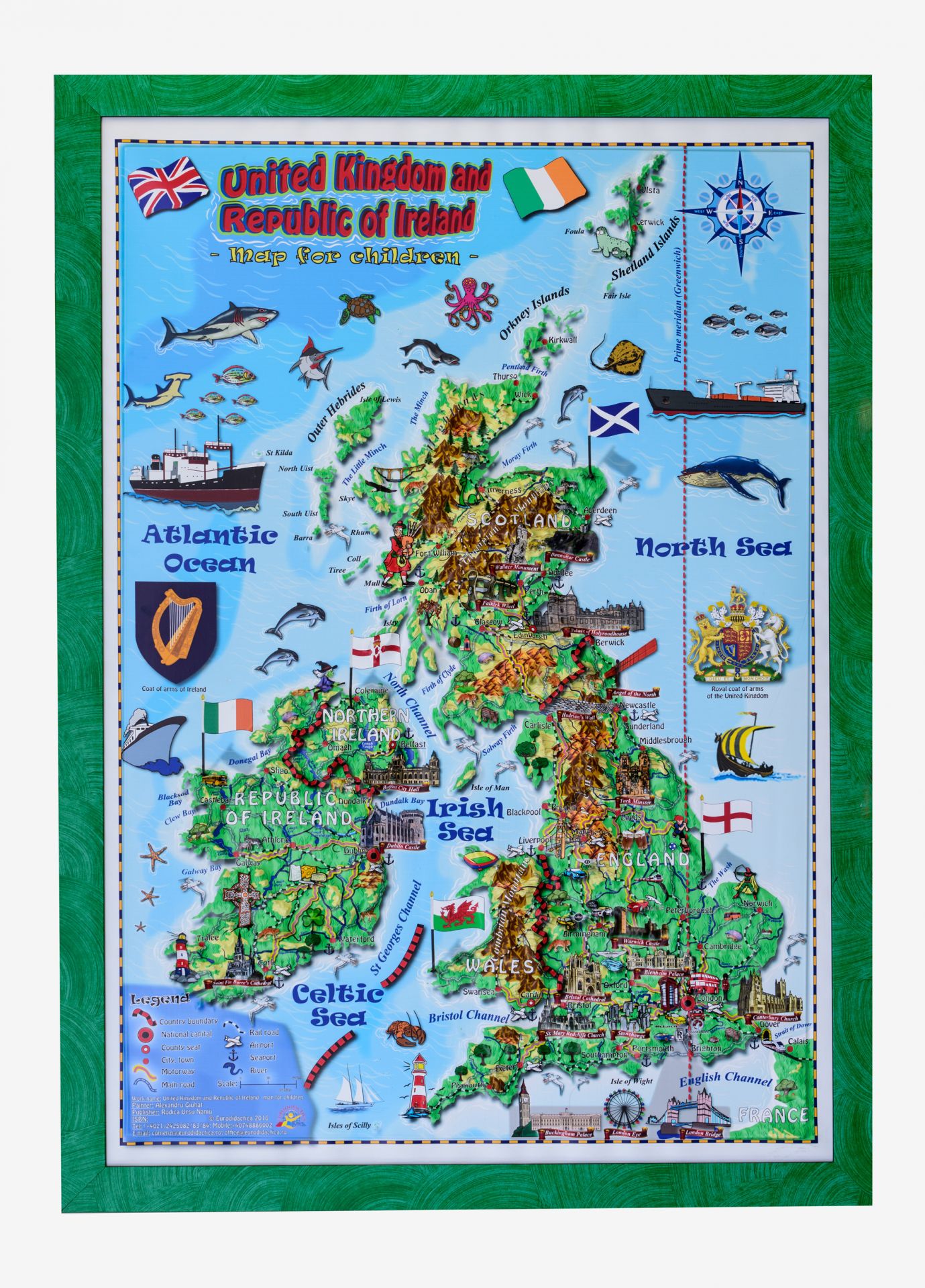
Our colorful and interactive 3D map brings out the adventurous spirit in your children and ignites their imagination. Designed using an advanced technology, this map allows kids not only to see, but also to touch different landforms,which in turn, enables them to get a more comprehensive understanding of the topography and the natural diversity of the United Kingdom & Ireland. This map will take your kids on a fascinating odyssey full of interesting discoveries: mountains, rivers, valleys and main cultural/historical landmarks of the UK & Ireland await them ahead.
Leave the boring geography behind and enjoy the ’’bumps’’!
Specifications: the map is made of PVC of 0.25 – 0.45 mm, with the frame
Dimensions: 700x1000 mm
ISBN: 978-606-8929-10-1

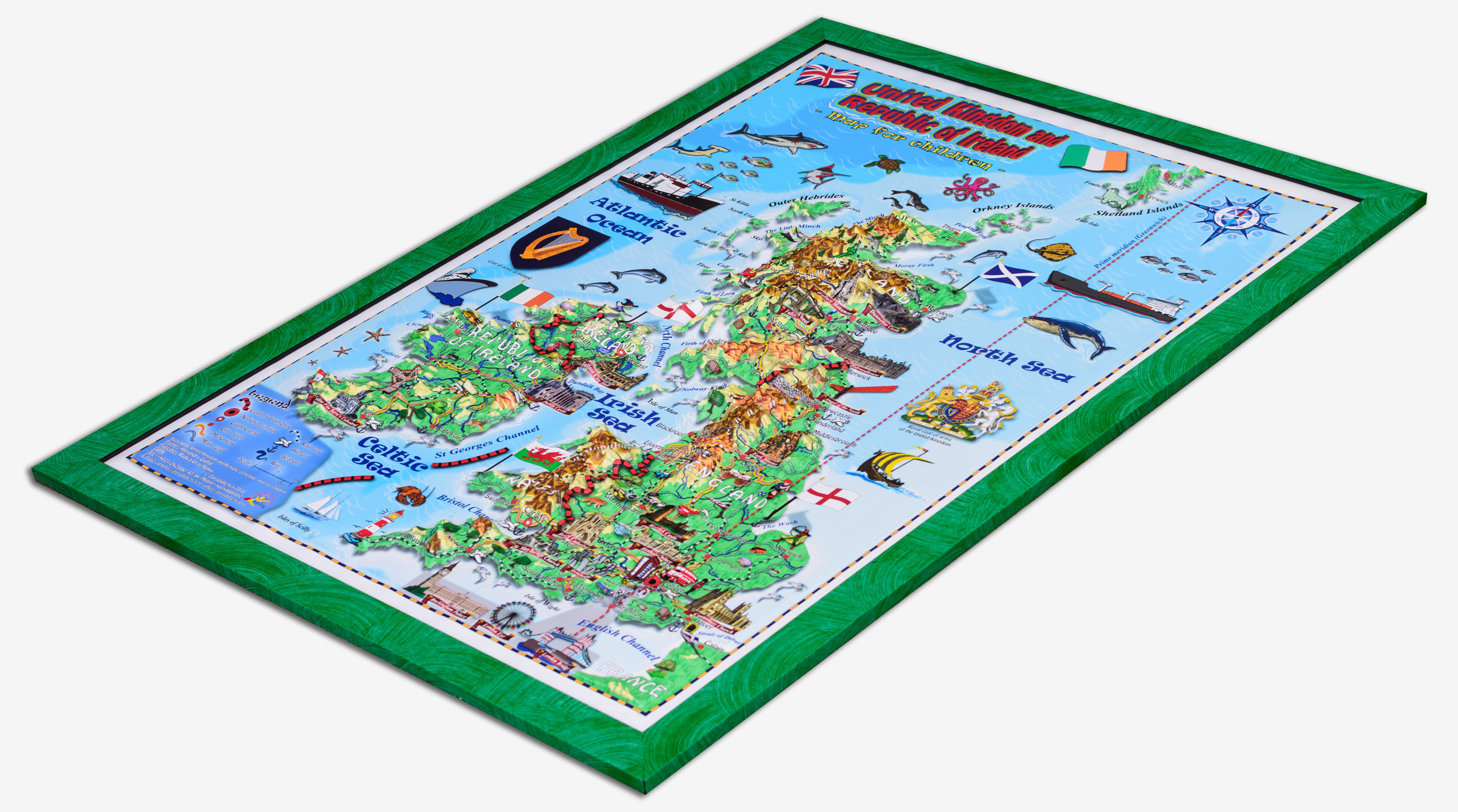
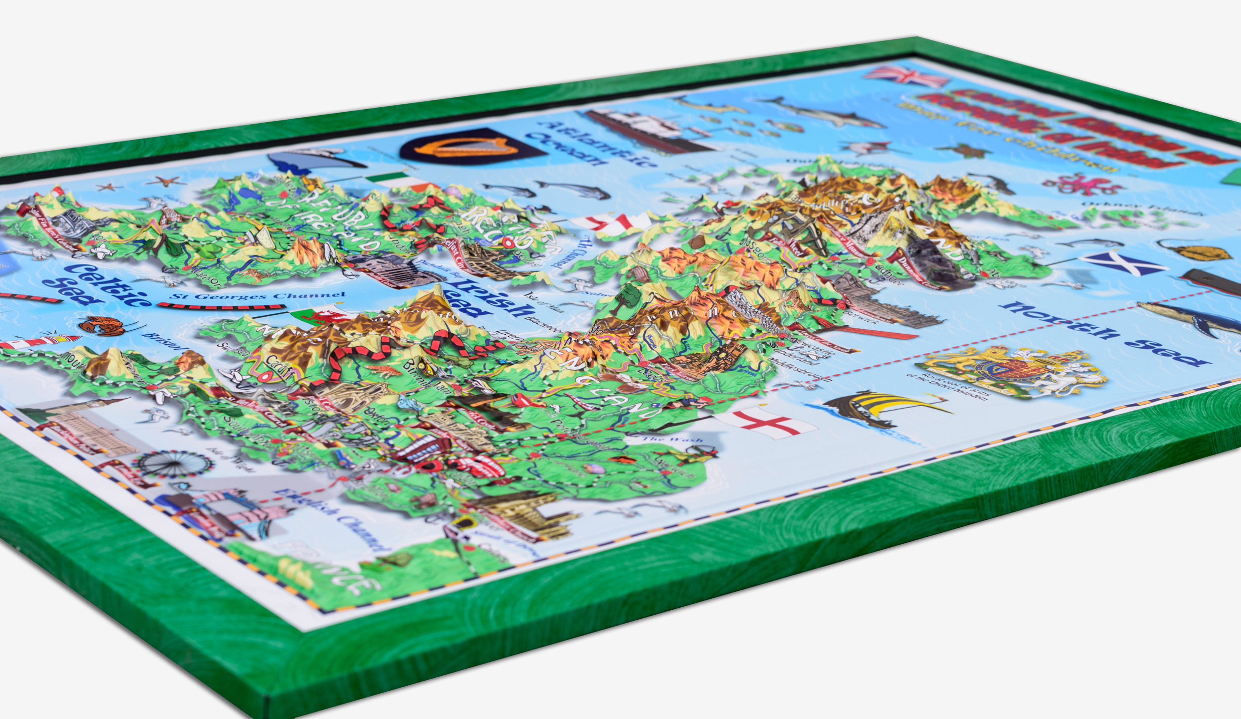
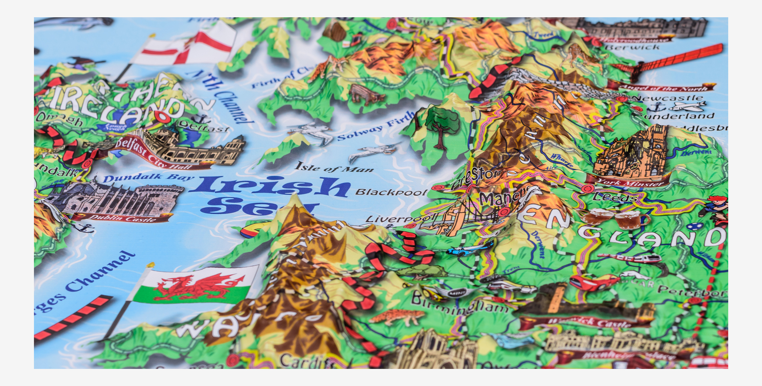


 Table interactive tip display
 Suporti pentru display interactiv
 Calculatoare tip OPS
 Table interactive whiteboard, cu videoproiector
 Echipament video conferintă și automatizări
 Pupitre conferinta
 Calculatoare
 Soft educațional
 Multifunctionale
 Echipamente audio
 Videoproiectoare
 Ecrane de proiectie
 Suporti videoproiector
 Videoproiectoare interactive
 Produse conexe
 Camere de documente
 Componente
") Panouri rigide, cu ramă ( de interior)
Panouri rigide, cu ramă ( de interior) ") Panouri rigide, cu ramă (de exterior, pentru afișaj stradal)
Panouri rigide, cu ramă (de exterior, pentru afișaj stradal)  Planse laminate, cu șipci
  Planșe laminate, fără șipci
 Harţi 3D pentru copii
 România şi Republica Moldova. Harţi 3D
 Europa
 Lumea
Lumea Matematica
 Explorăm natura și mediul înconjurător
 Dezvoltarea limbajului
 Harti pentru copii
 Educatie fizica
 Dezvoltare socio-emotionala
 Dezvoltarea limbajului
 Dezvoltarea cognitiva
 Harti pentru copii
 Limba si Comunicarea
 Matematica si stiinte ale naturii
 Om si societate
 Arte si tehnologii
 Harti pentru copii
 Fizica
 Geografie
 Astronomie
 Educatie civica
 Chimie
 Istorie
 Matematica
 Informatica
 Biologie
 Limba română
 Literatura romana
 Limba engleza
 Limba franceza
 Limba rusa
 Arte
Arte Accesorii
 Scaune gradinita
 Canapele, fotolii și pernuțe
 Mese gradinita
 Paturi gradinita
 Dulapuri gradinita
 Dulapuri metalice pentru scoli si gradinite
 Etajere gradinita
 Set mobilier MISTERELE UNIVERSULUI
 Set mobilier CASTEL
 Set mobilier CASTEL 2
 Set mobilier TRENULET
 Set mobilier TRENULET 2
 Set mobilier TRENULET 3
 Set mobilier ORAS
 Set mobilier POIENITA
 Set mobilier PADUREA FERMECATA
 Mobilier tematic pentru copii - Profesii
 Setul de mobilier „Scoala – Gradinita”
 Cutii pentru depozitare
 Componente mobilier
") Mobilier scolar individual (fix)
Mobilier scolar individual (fix)") Mobilier scolar individual (reglabil)
Mobilier scolar individual (reglabil)") Mobilier scolar dublu (fix)
Mobilier scolar dublu (fix)") Mobilier scolar dublu (reglabil)
Mobilier scolar dublu (reglabil) Scaune pentru elevi
 Statii de dezinfectare a mainilor
 Cuiere
 Catedre si mese
 Dulapuri
 Cabinet medical
 Rafturi metalice
 Mobilier pentru camine
 Biblioteci si arhive
 Table scolare
 Suprafete laminate
 Table magnetice din sticla
 Flipchart-uri
 Aviziere
 Laboratoare
 Consumabile si accesorii
 Organisere
 Suporti pentru harti
 Pereti despartitori
 Cancelarii
 Cantine si ospatarii
 Componente mobilier
 Seturi universale
 Bancute nivel liceal
 Bancute nivel gimnazial
 Scaune elevi
 Mobilier laborator
 Bancuri de lucru
 Bancuri de lucru pentru asamblare echipamente electronice
 Amfiteatru clasic
 Amfiteatru modern
 Amfiteatru avangardist
 Sali de seminar
 Componente
 Fotolii teatru
 Fotolii cinema
 Fotolii auditoriu
 Fotolii camine culturale
 Mobilier metalic vestiare
 Dulapuri metalice
 Rafturi metalice
 Mobilier metalic laboratoare
 Mobilier metalic: arhive si biblioteci
 Dulapuri ignifuge
 Mobilier metalic servere
 Mobilier metalic birouri
 Mobilier inox
 Sistem linguafonic fix
 Sistem linguafonic portabil
 Gimnastica
 Atletism
 Volei
Volei Fotbal
 Badminton
 Handbal
 Hokey
Hokey Tenis
Tenis Baschet
 Drapele
 Steme
Steme Material didactic
 Mobilier
 Jucarii educative